ADAMS COUNTY (as of 1878):
By an act of the territorial legislature, approved March 11, 1848, the county of Adams was created from Portage, and embraced a region circumscribed by a line commencing at the "northwest corner of Sauk county, and running due north to the middle of the Lemonwier river; thence down the main channel of that river to its mouth; thence down the Wisconsin river to the point where it crosses the north line of township thirteen; and thence due west to the point of beginning." The new county was attached to Sauk for all purposes.
By an act approved March 8, 1849, the boundaries of Adams were changed, the county greatly enlarged. By this act, it included all north of the middle of township fifteen north, in ranges two, three, four, five, six and seven east, to the north line of township twenty north. At this time the county contained about 1,435 square miles, of about 919,000 acres.
By an act of March 14, 1853, it was again enlarged, and made to include townships fourteen to twenty north, inclusive, lying in ranges two to seven east, inclusive.
By another act of the same date, it was organized for county and judicial purposes from and after the first Tuesday in April. By this act, also, it was organized into the five towns of Jackson, polls to be open at the house of Thomas Ritchie; Grand Marsh, voting to occur at the house of Mr. Peck Quincy, first election to be held at the house of H. W. Kingsbury; Necedah, first election at the house of Thomas Weston and Co.; Lemonwier, voting to occur at the house of Mr. Findlay. An election was ordered in these several towns for such officers as they were allowed by virtue of the organization.
The county seat was fixed, for a term of five years, on the southwest quarter of section seven, township sixteen north, of range five east -- the village of Quincy. The county was, by the same act, made part of the third judicial district.
The election, which occurred on the first Tuesday of April, resulted in the selection of E. S. Miner, county judge; W. J. Sayers, sheriff; S. G. Holbrook, clerk of the circuit court, and also county treasurer; W. H. Spain, clerk of the board of supervisors; William H. Palmer, register of deeds; D. A. Bigelow, district attorney; Caleb McArthur, county surveyor; and W. I. Webster, coroner.
The board of canvassers, which was composed of the chairman of the county board, assisted by two justices of the peace, decided that H. G.Holbrook could not legally hold two offices, and accordingly declared the office treasurer vacant, and appointed to that position Daniel Young. At a special meeting of the board in August, 1853, Stillman Niles gave bond to furnish a court room and three office rooms for the county.
By an act approved March 8, 1855, the question of dividing the county was submitted to the voters at the November election. The question for and against was fought with spirit, and not a little bitterness. It was carried by the friends of the division by a considerable majority, and the Wisconsin river became the western boundary line of Adams, and the new county of Juneau was formed. The new county remained attached to Adams for judicial purposes.
By this division the county seat was left on the western boundary of the county, and was distasteful to a large number of the citizens. As an outgrowth of this feeling, the legislature, by an act approved March 24, 1858, allowed the people to vote on the removal of the capital from Quincy to the village of Friendship. The vote resulted in a majority of one hundred and fifty-five for removal; and in January following, the books and records were taken to Friendship, where they have since remained.
PHYSICAL FEATURES AND RESOURCES
The general surface of this county is rolling. Along the Wisconsin river, however, it is, in places, quite broken, presenting some very romantic and wild scenery. The "Dells of the Wisconsin" are partially within the limits of Adams, in the southwestern part, and some of the most beautiful points are on its borders. "Cold Water Canyon" and "Witches' Gulch" extend back into the country a mile or more from the river, presenting some very beautiful and variegated scenery.
Toward the northern part, the view along the river is less grant, though the bluffs are always bold, and scene ever varied. This is due to the action of the water on the soft sandstone, which forms the banks, and which, by constant erosion, has been fashioned into an endless variety of forms. The bluffs vary in height, from a gentle ascent from the water's edge to ragged precipitous walls that rise abruptly two hundred feet or more.
The county has but few streams, the principal being the Big and Little Roche-a-Cri, White and Grignon's creeks. All these afford water power, and abound in the common kinds of fish. The soil of the county is below the average for cultivation, being quite sandy; however, in the southern part, there is considerable good land; and this region is the home of many thrifty and well-do-do farmers.
About 50,000 acres in the county are under cultivation -- the crops being corn, wheat, rye and hops, in the order of enumeration. Considerable attention is being paid to fruit raising, but it has been attended with only medium success.
The greater part of the county is covered with an inferior class of timber, such as the oak, ash and basswood, there being also a little pine toward the northern end. About twenty per cent, is marsh, some of which is adapted to cranberry culture, while other parts make valuable meadows. Sandstone is quarried at different places in the county, but is used only for local purposes.
The population in 1875 was 6,502, of which 5,271 were Americans; the rest being Swedes, Germans, Danes, and immigrants from other European countries.
The county has no railroad as yet. A few years ago an attempt was made, and a few miles graded south of Friendship, but the completion of the Wisconsin Central has caused the project to be discontinued. It will doubtless again be revived, and a road be put through. The present connections with the outer world are by daily stages to Kilbourn City.
EARLY HISTORY
The occupation of this region by the whites dates back to the time of trading posts and taverns, established for the supply and accommodation of the lumbermen going into the pineries of the upper Wisconsin.
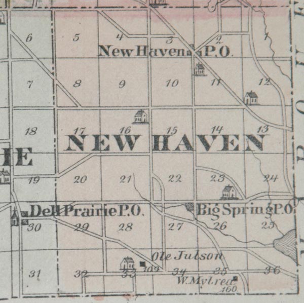
The first one of these posts within the present limits of Adams was established in 1838, in the present town of New Haven, within two miles of Big Springs post-office, b Jared Walsworth, a man who had experienced much of frontier life as an engineer on the Mississippi. He brought with him his family, and kept a tavern and general supply post. He died several years ago, but his wife still lives at the site of the old tavern. She was the first white woman in this region.
William Sylvester came about 1845, and located at what is now Grand Marsh post-office, establishing another tavern and feeding post. Shortly after his arrival cam Strong, who kept the same kind of a place on the Big Roche-a-Cri, not far from Cotton's about eight miles north Friendship. All of these establishments were on the old territorial road between Milwaukee and Stevens Point.
The first child born in this county was J. S. W. Pardee, son of George Pardee, in 1843, at the Walsworth tavern.
The first squatter in this county was George Stowell, who had arrived, in the employ of Walsworth in 1844. He located in New Haven town, and built a small frame shanty, 16 by 24, and began cultivating a little land. In the following year Amos Landt, Judge Smith, Robert Ramsey and his three sons, a man by the name of Winchell, and "Uncle" Ward, all squatted in the same town, around what is now Big Springs post-office. They all began to make improvements, by building log cabins and tilling small tracts of land.
In the fall of 1849 and spring of 1850, Thomas Rich, William Davis, Holland Carter, George Knox, Cotterel and Mathews, all settled in what is now Dell Prairie. Wells Tyler and Willard Armstrong settled along the banks of the Wisconsin the same year.
From the year 1850 to 1853, immigration into Adams county was very rapid, and the south part was quite well occupied by men who had come to remain.
In 1850, the first school house in the county was built. The site of this building was what is now known as Dell Prairie post-office. It was built by Thomas Rich, who hired Lewis Carter as teacher at $12 and board per month, and invited the neighbors to send in their children.
Reverend Anderson preached the first sermon in the county, in 1852, at the house of Mr. Rich, who paid him one dollar a visit. He afterward grumbled at the salary, and thought they ought to furnish him a conveyance. Mr. Rich thereupon bought him a horse for $65, and told him to wear his legs out in the good cause. A church was erected in 1854, at the Dell Prairie post-office, and Rev. C. L. Fisher, a Baptist minister, was employed to regularly supply the pulpit.
The first white settler who died was one Horton, who was killed in the summer of 1850, while digging a well.
In 1851, the land in this region was surveyed, and it became possible to secure good titles. The land office for this region was at Mineral Point, and earl on the heels of the survey forty-five men started in one day to enter land at the sales.
During the squatting days the settlers had a club for the mutual defense of each other, and for their protection against any encroachment on claims already taken. Their law was, at times, rather severe, but always effectual; the intruder had to "pick up" and leave, or he would be assisted in a very impromptu manner. The two towns, Dell Prairie and New Haven, are the best settled, and the richest in the county.
There are still tracts of land in the northern part of the county owned by the state and general government, for sale at a low figure. In these northern towns there are found deposits of bog iron ore, and also some beds of kaolin.
THE PRESS
The first newspaper in Adams county was started in 1858, the first copy being issued the second week in May. It was published by Julius Converse Chandler, now of Morris, Minnesota. The name of this sheet was the Adams County Independent. Chandler was induced to start this paper by the people of Friendship as a lever by which to assist in moving the county seat to that place. The county seat came, but it is said that the people forgot their pledges. It was discontinued in 1862. In the meantime the Adams County Press had been started in 1860, by the "Press Publishing Company," but really under the direction of S. W. Pierce, who still issues it weekly at the county seat.
FRIENDSHIP
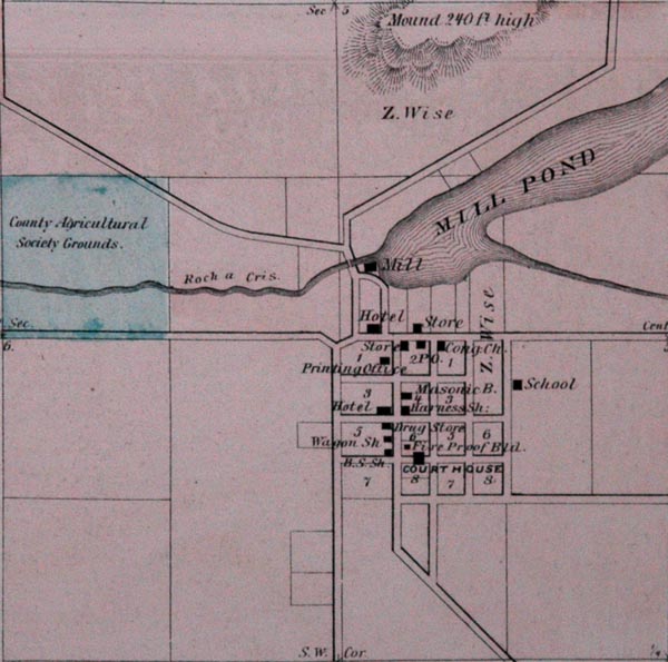
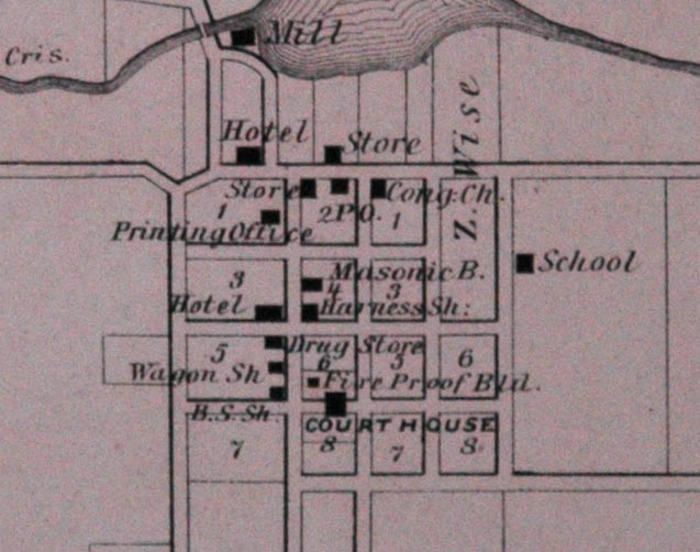
The village of Friendship is the capital of this county. It is situated on section five, in the town of Adams. This point was first settled in 1856, by people from Friendship, Alleghany county, New York. Of the original settlers, only W. R. Newton and family, and O. H. Wait and family, now remain. The village has a population of about four hundred, who are engaged in the various industries tributary to an agricultural region.
The public buildings are the court house, a frame building 32x46, two stories high, having a stone fire proof vault in which the papers are kept secure; a fine two story school house, 30x46; and one good church building, erected by the Congregational society, and jointly occupied by that and the Methodist society. Friendship is the largest village in the county. A daily stage runs between this place and Kilbourn City, on the St. Paul railway, in Columbia county.
|
